Automated Modelling of Tunnels
Tunnels must be regularly monitored to meet safety requirements and to prevent excessive deformation or displacement. Tunnels are currently monitored by measuring a few benchmarks using total stations or other...
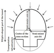
Tunnels must be regularly monitored to meet safety requirements and to prevent excessive deformation or displacement. Tunnels are currently monitored by measuring a few benchmarks using total stations or other...
At Bentley System’s annual conference for infrastructure thought leaders, CEO Greg Bentley presented a keynote speech. He stated that since Bentley Systems’ acquisition and assimilation of ContextCapture software in 2015, the...
When it comes to 3D modelling for construction, what are the advantages and disadvantages of photogrammetry versus Lidar in terms of accuracy, complexity and cost? Breaking away from laser measurement...
Due to the rapid changes of urbanisation, up-to-date, complex and realistic building models enriched with facade features are increasingly in demand in many countries. The Mobile Laser Scanning technique is...
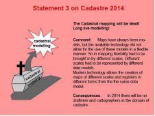
The Land Administration Domain Model (LADM) makes a significant contribution to understanding the importance of data modelling in the domain of land, land administration and land management. The ‘Cadastre 2014’...

Arkadiusz Szadkowski is senior business development manager of reality mapping, imagery & remote sensing at Esri. He is passionate about leading the change towards 3D GIS and bridging the gap...

Both vertical and oblique aerial images have their own advantages, making them valuable in different reality mapping applications. So how can you choose between the two? This comparison will help...
Clark Labs of Clark University has added a new video to the video series on its website. This latest video, entitled REDD Deforestation Modelling with Land Change Modeller in IDRISI,...
Mentum and Intermap Technologies, USA, have entered into a collaboration for the delivery of a new generation of height-attributed land-use geodata that addresses the propagation modelling needs of the wireless...
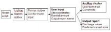
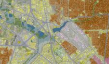
Estimating rainfall discharge is difficult in large catchment areas with varying topography. This leads to widespread inadequacy in culvert design, with resultant damage to these and other drainage infrastructure during...
This site uses cookies. By continuing to use this website, you agree to our Cookies Policy. Agree