Radar Altimetry Gains Altitude in Venice
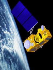
Scientists have gathered in the Italian 'floating city' of Venice this week to talk about radar altimetry: measuring the heights of the global sea surface, freshwater bodies, land and ice...
Scientists have gathered in the Italian 'floating city' of Venice this week to talk about radar altimetry: measuring the heights of the global sea surface, freshwater bodies, land and ice...

Esri chief scientist Dawn J. Wright, PhD, has received the Association of American Geographers (AAG) Presidential Achievement Award. Presented at the AAG annual meeting on 28th February 2012, the award...
HITT NV signed today the Share Purchase Agreement with the owners of IVS 3D. IVS 3D, founded in 1995, has developed highly sophisticated commercial products for marine information visualization, processing...
Optech is to roll out a line of high-performance aerial imaging systems making use of the recent acquisition of Geospatial Systems, Inc. (GSI). The new consolidated product line, to be...
The 1st Conference on Spatial Statistics 2011: Mapping Global Change is to be held from 23rd to 25th March 2011 at the University of Twente, Enschede, The Netherlands. Spatial statistics...
Nowadays, every child with a home PC has the technology, but in 1993 photo-realistic real-time rendering of geo-specific images was available only to supercomputer users. That same year, Tiltan Systems...
Since 1994 the OGC has operated with a global agenda for achieving interoperable geoprocessing. Our members, technology users and providers, collaboratively develop interface and encoding standards of local to global...
The European Space Agency is about to launch a mission to investigate the Earth's gravitational field and to map the reference shape of our planet - the geoid - with...
The European Space Agency and Thales Alenia Space have signed a €305 million contract to provide the first Sentinel-3 earth observation satellite, devoted to oceanography and land-vegetation monitoring, as part...
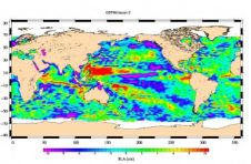
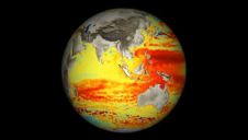
Less than a month after launch, the NASA-French space agency Ocean Surface Topography Mission (OSTM)/Jason 2 oceanography satellite has produced its first complete maps of global ocean surface topography, surface...
This site uses cookies. By continuing to use this website, you agree to our Cookies Policy. Agree