Airborne Lidar Bathymetry
Although operational for more than twenty years, Airborne Lidar Bathymetry (ALB) has rarely been used in riverine areas. The US Bureau of Reclamation adopted it to study how flow change...
Although operational for more than twenty years, Airborne Lidar Bathymetry (ALB) has rarely been used in riverine areas. The US Bureau of Reclamation adopted it to study how flow change...
SBG Systems is a leading supplier of inertial motion sensing solutions, from miniature to high accuracy. Combined with cutting-edge calibration techniques and advanced embedded algorithms, SBG Systems’ products are ideal...

senseFly’s field-proven, end-to-end drone solutions simplify the collection and analysis of geospatial data, allowing surveying and GIS professionals and their clients to make better decisions, faster. Founded in 2009 by...
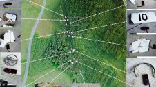
DroneMetrex, an Australian manufacturer of the TopoDrone photogrammetric mapping UAV systems, has introduced a solution for directly georeferenced mapping from UAVs. According to the company, the difference and main advantage...
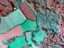
DroneMetrex has announced that near-infra-red (NIR) mapping data has been captured with the TopoDrone-100. The radiometric quality has been achieved because DroneMetrex specialists performed the necessary camera modifications and have...
The Taiwan Aviation Safety Council (ASC) successfully deployed a cyberQuad UAV as part of its investigation into the crash of a TransAsia Airways ATR-72-500 aeroplane on the island of Hoko, west...
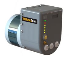
YellowScan is pleased to announce the global launch of its new Lidar UAS surveying solution with its highest accuracy and most dense geo-referenced point cloud data: 3cm accuracy – 300...
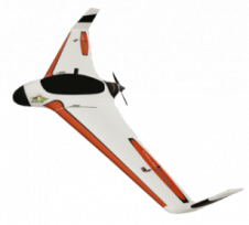
Drone manufacturer ScientificAerospace together with mapping company DroneMetrex from Adelaide, Australia, has developed a photogrammetric mapping solution that offers new possibilities for the geospatial industry. Building on the advantages of ScientificAerospace’s experience...
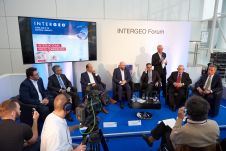
As the leading event for the global geoinformation community, Intergeo 2016 provided a forum for 531 exhibitors to present their latest products and around150 speakers to disseminate their innovative thoughts....
Photogrammetric mapping is the new 'hot topic', although the concept has been around since Leonardo da Vinci's time and it has been in use in practice for over a century. Drone...
This site uses cookies. By continuing to use this website, you agree to our Cookies Policy. Agree