Yuneec Launches RTK Variant of H520 Hexacopter
UAV manufacturer Yuneec has released a new version of its commercial hexacopter platform with an integrated RTK unit from Swiss firm Fixposition. The H520 RTK is capable of 1cm +...
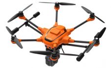
UAV manufacturer Yuneec has released a new version of its commercial hexacopter platform with an integrated RTK unit from Swiss firm Fixposition. The H520 RTK is capable of 1cm +...

DJI, a world leader in civilian drones and aerial imaging technology, has announced the global rollout of the Phantom 4 RTK, a high-precision aerial survey drone that combines centimetre-level navigation...
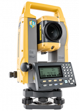
Sokkia has introduced the latest addition to its iM line of manual total stations designed to be cost effective, but still provide powerful performance, the iM-50. “Whether operators need an...

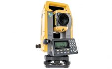
Topcon Positioning Group has announced an addition to its GM line of manual total stations designed to provide fast and accurate measurements in a cost-efficient package - the GM-50. The...
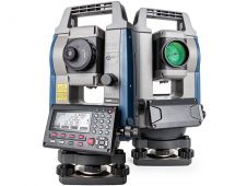
Topcon Positioning Group has announced the GM-100 total station designed to provide a powerful EDM along with advanced integrated communications technology in a manual package. The GM-100 features dual-axis compensation designed to ensure...
Topcon Positioning Group has announced the GM-100 total station designed to provide a powerful EDM along with advanced integrated communications technology in a manual package. “It delivers the latest technological...
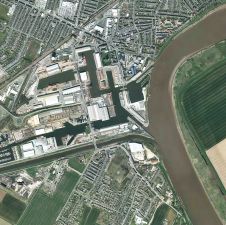
Yorkshire Water is using high resolution aerial photography to help manage its water network and assets over an area of nearly 15,000 square kilometres. The company has signed a new...
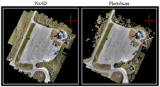
Anyone involved with structure-from-motion (SfM) photogrammetry has probably questioned which type of processing software is necessary for them to produce quality 3D point cloud data. Many SfM software packages exist...
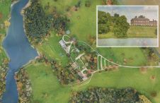
The National Trust has turned to aerial laser mapping to create accurate 3D models of the Dudmaston Hall estate in Shropshire, England. Working with aerial mapping company Bluesky, the Trust...
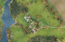
The National Trust has turned to aerial laser mapping to create accurate 3D models of the Dudmaston Hall estate in Shropshire, England. Working with aerial mapping company Bluesky, the Trust...
This site uses cookies. By continuing to use this website, you agree to our Cookies Policy. Agree