James Norris
James Norris is International Policy Advisor at Ordnance Survey where he works to promote the vital role that geography and geospatial data has in transforming economies, sustaining the environment, and...

James Norris is International Policy Advisor at Ordnance Survey where he works to promote the vital role that geography and geospatial data has in transforming economies, sustaining the environment, and...

Innovative developments based on quantum physics will lead to further disruption of our professional field over the coming decade, predicts Hansjörg Kutterer who, besides being president of DVW, is also...

How can organizations and businesses advance their geospatial maturity in the coming years? The latest version of the Future Trends in Geospatial Information Management report by UN-GGIM captures technological and...

The Geospatial Information Roadshow 2021, hosted by the Ministry of Land, Infrastructure and Transport (MOLIT) of Korea and organized by Korea Land and Geospatial Informatix Corporation (LX), will open in...
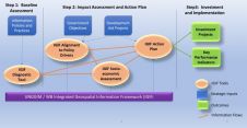
Norway's national mapping agency has contracted the UK's ConsultingWhere to accelerate NSDI development in Georgia, Moldova, Kyrgyzstan and Ukraine using the IGIF. ConsultingWhere, a UK-based geospatial consultancy company, secured the contract...
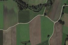
Copernicus Sentinel-1 radar data along with interferometric processing can map crop types from space even more effectively than the traditional method using optical satellite images, according to a recent study....

How are technological developments, skills shortages and the pandemic affecting the broader geospatial community in Australia? To find out, GIM International spoke to Paul Digney, president of the Surveying and...
European Space Imaging has been awarded a fourth multi-year agricultural framework contract to deliver an estimated 1.2 million square kilometres of very high resolution (VHR) satellite imagery and associated services...

Qatar University (QU) has unveiled plans for the Digital Qatar Project. Drone imagery will be used for the purposes of aerial surveying at QU, with the participation of specialists from...

Barbara J. Ryan has started the new year by becoming the executive director of the World Geospatial Industry Council (WGIC). Sanjay Kumar concluded his term as the chief executive and will...
This site uses cookies. By continuing to use this website, you agree to our Cookies Policy. Agree