Combining precision and power: the Mars Pro GNSS receiver
The Mars Pro Laser RTK is the third addition to ComNav’s Universe series of GNSS receivers, following on from the Venus Laser RTK and Mars Laser RTK. According to ComNav...
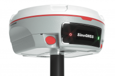
The Mars Pro Laser RTK is the third addition to ComNav’s Universe series of GNSS receivers, following on from the Venus Laser RTK and Mars Laser RTK. According to ComNav...
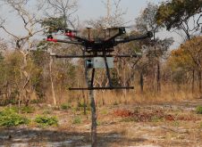
British mine-clearance charity The HALO Trust partnered with Routescene to undertake a UAV Lidar project in Cuito Cuanavale, in the Angolan province of Cuando Cubango. This case study demonstrates the...
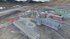
Nestled in the high Arctic Archipelago of Svalbard, the Sveagruva coal mine and mining settlement once buzzed with activity until its closure in 2016. An extraordinary project is now underway...

The integration of geospatial information software (GIS), remote sensing and surveying and mapping data has accelerated in recent years. Meanwhile, new technologies such as AI models and ChatGPT are emerging...
Trimble recently released the Trimble Terra Office add-in for Esri ArcGIS Pro. The add-in is a new product in the Terra Office suite of desktop solutions for integrating Trimble TerraFlex...

With the theme of ‘Geospatial Intelligence, Elevated by Integration’, the 2023 Geospatial Information Software Technology Conference commenced at the China National Convention Center in Beijing on 27 June. Government leaders...

The University of Bradford has taken delivery of the UK’s first Leica TRK700 Evo – a vehicle-mounted mobile mapping system capable of capturing two million data points every second to...
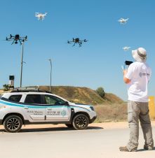
Israel’s national roads company is embarking on a large-scale, multi-year project to digitize its entire network. Surveying company Kav Medida has been awarded the contract to map the northern half...
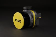
ROCK Robotic has announced the launch of its latest Lidar mapping system, the R3 and R3 PRO. The R3 product line introduces advanced hardware components into a lightweight, integrated 3D...
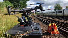
Plowman Craven has introduced Vogel Freedom, a UAV survey system designed for rail infrastructure surveying. Vogel Freedom is a survey-grade solution that surveys tracks without physical access. A novelty in...
This site uses cookies. By continuing to use this website, you agree to our Cookies Policy. Agree