Sakshi Singh
Sakshi Singh is a content manager at the Association of Geospatial Industries in India, where she contributes to editorial curation and design, research and documentation, marketing and outreach, and stakeholder...

Sakshi Singh is a content manager at the Association of Geospatial Industries in India, where she contributes to editorial curation and design, research and documentation, marketing and outreach, and stakeholder...

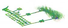
A RIEGL VZ-400i 3D terrestrial laser scanner was deployed in Peru to create a high-resolution digital 3D terrain model of an ancient fortress. This is a good example of how...
Read how SLAM technology was used to scan a former mine complex in Poland to ensure safety during a project to preserve the site's historical, educational and functional significance. Underground cultural...
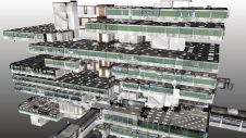
IBKS is a digital solutions and management consulting firm offering built-environment services in the healthcare space. The firm recently tested its innovative NavVis and PointFuse workflow in a huge, complex...

Matterport has introduced the all-new Matterport Pro3 Camera along with major updates to its industry-leading digital twin cloud platform. The Pro3 is a breakthrough in 3D capture technology, ready to...

The Norwegian-based company formerly known as KVS Terratec has relaunched under the name Field. This new name reflects the merging of several entities to form a unique total supplier and...
Established as an advanced and comprehensive geospatial software, Global Mapper Pro excels in terrain analysis, point cloud editing, drone-collected image processing and much more. Recent versions of the programme have...

Blue Marble Geographics® is a US-based software company offering geospatial technology tools with a particular focus on coordinate conversion and management, lidar and photogrammetric point cloud processing, and user-driven product...
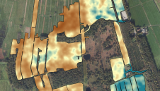
The Earth sciences sector is rapidly adopting UAVs. These two studies have explored combining a gamma-ray spectrometer with a drone to map soil properties. In the Earth sciences sector, sensors...
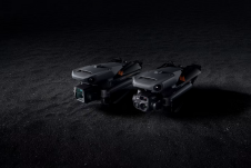
DJI has introduced its new DJI Mavic 3 Enterprise series designed to reimagine what drones can do for business, government, education and public safety. The DJI Mavic 3E and DJI...
This site uses cookies. By continuing to use this website, you agree to our Cookies Policy. Agree