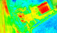
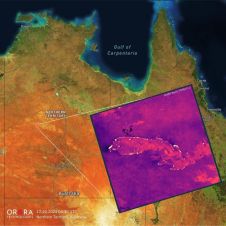
Found 3171 results
Sort by

Pioneering precision in Swedish skyscrapers

The revolutionary use of active GNSS control points and cutting-edge geomatics equipment is setting new standards for accuracy in the construction of high-rise architecture, as demonstrated by this skyscraper project...

Read more

Point Cloud Processing

Leica Geosystems announces the exclusive distribution of RealityLINx Model 5.4 - powered by Leica point cloud Engine (pcE) technology. RealityLINx Model 5.4 speeds and simplifies the processing of as-built laser...

Read more

Image Processing Application

ITT and ESRI have taken on a strategic partnership to integrate their respective software technologies. This integration delivers advanced, image processing and analysis capabilities to the ArcGIS platform and expands...

Read more

Peak performance in mobile mapping

It can still be difficult to achieve centimetre-level accuracy in mobile mapping, especially in GNSS-denied or challenging areas such as in deep urban canyons, under foliage or through tunnels. However,...

Read more

TerraPos Post-processing Software

The Norwegian company Terratec has introduced software capable of accurate positioning based on post-processing of GPS-observations, without the use of reference stations or DGPS services. Typical accuracy for kinematic applications...

Read more