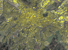
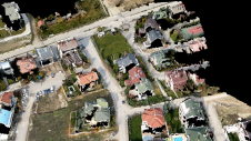
Use of AI to detect rooftop solar potential
Global climate change and, in some areas, the lack of a cheap and reliable energy supply are contributing to the expansion of photovoltaics, both regionally and worldwide. In addition to...
Global climate change and, in some areas, the lack of a cheap and reliable energy supply are contributing to the expansion of photovoltaics, both regionally and worldwide. In addition to...
MariaDB has acquired CubeWerx, a leader in geospatial solutions, for an undisclosed amount. With this acquisition, MariaDB adds cloud-native, scalable geospatial capabilities that the company plans to offer through its...

Morteza Esfandiari, MSc, is a geospatial technician with McElhanney Ltd. Morteza received his MSc in Geodesy and Geomatics Engineering from the University of New Brunswick in 2021. His research interests...
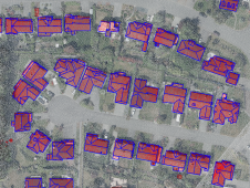
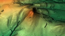
How can artificial intelligence and deep learning lead to a robust process for 3D city modelling? And what are some of the challenges? Automated classification and object detection in Lidar...

Read this guide to the main 3D data representation methods to understand the key differences and choose the best method for your specific applications. The 3D data jungle in today’s...
Woolpert has been selected to collect, process and deliver topographic mapping across more than one quarter of Nigeria, or roughly 258,000 square kilometres, under a US$4.4 million contract with the...
When it comes to monitoring the condition of roads, UAV technology can overcome many of the downsides associated with traditional methods, which can be time-consuming, labour-intensive and sometimes subjective. This...
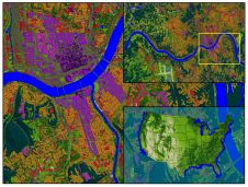
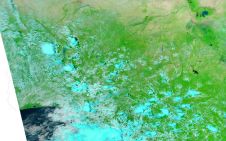
Land Info Worldwide Mapping recently completed up-to-date 10m-resolution thematic raster GIS data covering all 50 US states. Optimized for low-band (broad-area coverage) 5G wireless planning, the dataset supports additional applications including...
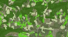
Thanks to machine learning, Victoria's Department of Environment, Land, Water and Planning (DELWP) is making it easier than ever before to get information about the tree cover extent state-wide. Victoria...
Woolpert has acquired AAM, a global geospatial services company that specializes in aerial mapping, surveying, GIS and the development of innovative geospatial processes and technologies. AAM is headquartered in Australia...
This site uses cookies. By continuing to use this website, you agree to our Cookies Policy. Agree