Why hasn’t the Earth observation industry taken off?
The Earth observation industry seems to be on a slow burn – but why? Brace yourself for a ‘rollercoaster ride’ through Earth observation as this article unravels the mysteries behind...

The Earth observation industry seems to be on a slow burn – but why? Brace yourself for a ‘rollercoaster ride’ through Earth observation as this article unravels the mysteries behind...

Land Info Worldwide has assembled a team of renowned geospatial companies to help plan the roll-out of 5G networks across Europe. Land Info is already the premier provider of mapping...
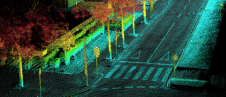
Ordnance Survey, the national mapping agency for Great Britain, was in need of a faster and more cost-effective way to collect georeferenced point cloud data, because the existing method was not sustainable in the long term. The Ordnance Survey team turned to Datron Technology and OxTS to help them develop a convenient, low-cost, ‘off-the-shelf’ mobile mapping system. Ordnance Survey, the national mapping agency for Great Britain, was in need of a faster and more cost-effective way to collect georeferenced point cloud data, because the existing method was...

Hexagon has announced its acquisition of Qognify, a leading provider of physical security and enterprise incident management software solutions. Serving more than 4,000 customers worldwide in banking, government, logistics, manufacturing,...

Besides its excellent technical content, the recent FIG Congress in Poland was a place for enthusiastic reunions and for forming new friendships. Wim van Wegen looks back on the event,...

R-evolution has been awarded a contract to supply multidimensional intelligent mapping services of The Bahamas’ seabed. The services are part of a larger initiative to enable the island nation to...

In which direction is the geospatial industry heading? Which core activities will companies focus on? How will the rapidly progressing technological advances shape the future? The recent edition of HxGN...

Hexagon has announced that Paolo Guglielmini will succeed Ola Rollén as president and CEO of Hexagon AB, effective from 31 December 2022. Hexagon is a global leader in digital reality...
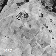
Only a small fraction of the information content in aerial films has ever been recorded on paper maps, most of which are inaccessible. The use of artificial intelligence (AI) to...
A dynamic field of view feature was used to overcome the inability of Lidar laser beams to penetrate persistent cloud cover in this project in Cameroon. In Lidar surveys, minimizing...
This site uses cookies. By continuing to use this website, you agree to our Cookies Policy. Agree