Mapping Indoor Spaces with an Advanced Trolley
Few museums, shopping centres, airports and other indoor spaces have been mapped, although the demand for detailed 3D models of such spaces is accelerating rapidly. Here, the authors present a...
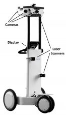
Few museums, shopping centres, airports and other indoor spaces have been mapped, although the demand for detailed 3D models of such spaces is accelerating rapidly. Here, the authors present a...
Hexagon was recently awarded the first and second prizes in the Wichmann Innovations Award programme held during the Intergeo conference and trade fair in Stuttgart, Germany. Honours went to Leica...
Hexagon, a leading global provider of information technologies that drive productivity and quality across geospatial and industrial enterprise applications, recently was awarded the first- and second-place prizes in the Wichmann...
Data is essential for any GIS. Fortunately today there is a vast array of rapid data capture technologies. GIS Professional’s sister publication Geomatics World reports from the world’s biggest exhibition...
Opti-cal Survey Equipment and GeoSLAM combine to offer you the latest in 3D laser scanning. The ZEB1 is the first truly mobile lightweight hand-held scanner which captures data of previously...
The organisers of the UK’s largest geospatial event, GEO Business 2016, which will take place in London from 24-25 May, are presententing a commercial workshop programme that explores pioneering technology and...

CartoConsult recently signed a joint venture agreement with Proteus to develop and promote the use of the latest laser scanning technology. As new systems such as handheld mobile mappers, UAV-mounted sensors...

GeoBusiness returned to the Islington Business Design Centre for its third year with a larger exhibition, more visitors and, if anything, an even buzzier atmosphere. GW’s team at the event...
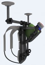
3D Laser Mapping will launch an innovative multi-platform mapping system at Geo Business 2016. The new platform, named ROBIN, is the first of its kind on the market and provides...

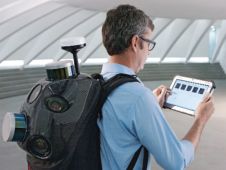
Over the last few years street-level mobile mapping and reality capturing has quietly become one of the most important geospatial mapping technologies. There are already hundreds of mapping vehicles collecting...
This site uses cookies. By continuing to use this website, you agree to our Cookies Policy. Agree