UNAM selects RIEGL sensor as its first aerial Lidar system
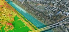
The University of Nacional Autónoma de México (UNAM) has recently procured a RIEGL VQ-1560 II-S airborne system through its Institute of Geography. It has been added to the R&D project...
The University of Nacional Autónoma de México (UNAM) has recently procured a RIEGL VQ-1560 II-S airborne system through its Institute of Geography. It has been added to the R&D project...

3D visualization is at the heart of many geospatial data applications. Progress in 3D visualization has drastically reduced barriers to entry for new products based on large datasets, thanks to...
Leica Geosystems, part of Hexagon, has launched the Leica TerrainMapper-3 airborne Lidar sensor, featuring new scan pattern configurability to support the widest variety of applications and requirements in a single...

As we enter the era of smart manufacturing, the reliability of data is growing in significance and data standardization is becoming increasingly important. According to JP Kelly, associate director and...

JOUAV has released the JoLiDAR-1000 Lidar sensor designed specifically for uncrewed aerial vehicles (UAVs or ‘drones’) as the latest addition to its array of high-performance Lidar sensors for use in...

Mosaic has partnered with Movella aimed at redefining precision and efficiency in mapping and 3D reconstruction projects. Mosaic is specialized in mobile mapping camera systems, while Movella is a renowned...

A topobathymetric Lidar survey was conducted to support flood preparedness in Canada. Which techniques achieved exceptional precision, and what were the logistical challenges? Find out more in this article. As...
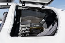
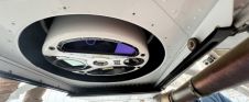
Diamond Aircraft and Vexcel Imaging have announced the next collaboration for a further expansion of Diamond’s special mission aircraft high-end sensor portfolio. The partnership will integrate the UltraCam Dragon 4.1...
Make Underwater Exploration Easier Focus on acoustic sounding technology, Hydro-Tech had developed different products widely applied in underwater exploration industry. Nowadays Hydro-Tech owns completely independent and controllable core technologies in...
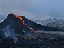
The Icelandic authorities have commissioned Acecore to map the extent and aftermath of the Eldvörp-Svartsengi volcanic system eruption using its high-end drone solutions. Grindavík, a fishing village on the Reykjanes...
This site uses cookies. By continuing to use this website, you agree to our Cookies Policy. Agree