Sensor Vision Inc
It can still be difficult to achieve centimetre-level accuracy in mobile mapping, especially in GNSS-denied or challenging areas such as in deep urban canyons, under foliage or through tunnels. However,...
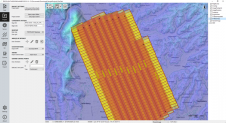
The TatukGIS Developer Kernel (DK) plays a key role in the Topoflight software suite (Missionplanner for optimal flight paths, and Navigator for precise data acquisition). In the realm of vast...

Recently unveiled by Vexcel Imaging, the groundbreaking UltraCam Dragon 4.1 represents one of the market's most advanced, progressively designed and seamlessly integrated hybrid aerial mapping systems. Tailored for high-resolution mapping...
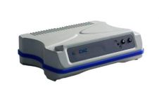
CHC Navigation’s N71 GNSS Sensor has been designed to bring a cost-effective positioning solution for RTK network operators, precision farming and machine guidance system integrators and marine survey professionals. It...

Trimble has introduced the latest version of its core geospatial automated monitoring software: Trimble 4D Control version 6.3. The software provides automated movement detection to enable informed decisions about infrastructure...
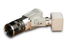
Specim, Spectral Imaging is launching a high-resolution hyperspectral imaging sensor with exceptional performance and the dimensions required for Unmanned Aerial Vehicles (UAV) and other challenging applications. The V10M sensor operates...
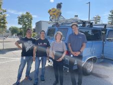
Surveyors of the Month: Team Geokno This month's Survey Team Geokno. Geokno (www.geokno.com) deals in geospatial knowledge products and services, taking advantage of the long research and development tradition of...

The Leica TM30 Sensor is designed for high-precision measurements and combines automatic, fast and silent operation to ensure that even the smallest movement in all monitoring applications is detected. The...

RIEGL has recently added the VUX-18024, a lightweight and versatile UAV-Lidar sensor for high-speed surveying missions, to its portfolio. This once again underlines the Austrian company’s pioneering role as a...
This site uses cookies. By continuing to use this website, you agree to our Cookies Policy. Agree