Welcome to the New Geospatial
Teledyne Optech and Teledyne CARIS have united to form Teledyne Geospatial in response to evolving marketplace needs. Under the Teledyne Imaging group, the harmony between the two business units is...
Teledyne Optech and Teledyne CARIS have united to form Teledyne Geospatial in response to evolving marketplace needs. Under the Teledyne Imaging group, the harmony between the two business units is...
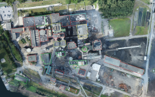
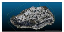
Construction sites and, especially, demolition sites are often challenging environments for surveyors. Nevertheless, effective project management and financial control depend on accurate and timely information about the volumes of materials...
Teledyne Optech and Teledyne CARIS have united to form Teledyne Geospatial in response to the evolving marketplace needs. Under the Teledyne Imaging group, the harmony between the two business units...
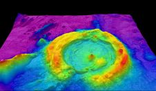
Bathymetric Lidar is a technique that is used to capture geospatial data of coastlines and waterbodies. The method has the potential to facilitate the fast and efficient creation of hydrographic data, and more...
The Finnish Geospatial Research Institute (FGI) has recently added the RIEGL VQ-840-G airborne laser scanner to its impressive collection of sensors. FGI innovators are true scientists, moving the 3D industry...
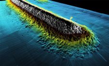
How can AUVs be reliably used to map the 3D structure of the underside of sea ice, especially now that the climate crisis makes it more important than ever to...
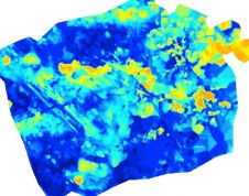
Accurate bathymetric mapping of shallow areas is essential for many offshore activities. Through Structure from Motion (SfM) and Multiview Stereo (MVS) techniques, images can provide a low-cost alternative compared to Lidar...
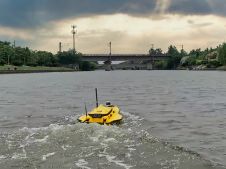
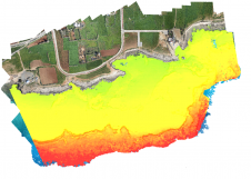
This paper explores the various features of the Apache USV series for efficient seafloor-level mapping. The CHCNAV hydrographic survey software is used for data recording and analysis. It provides results...

The 2019-2020 year has been a busy one with the Working Groups of Commission 4 focussing on representing FIG at a number of events and forum to gain insight to...
Some of the challenges demanding innovative surveying approaches and technologies are rapid urban growth, smart energy, cleaner mobility, and ‘land rights for all’. Sensing technologies, spatial data processing methods, and...
This site uses cookies. By continuing to use this website, you agree to our Cookies Policy. Agree