Symposium on Innovative Technologies for Land Administration
This symposium, held at the University of Wisconsin in Madison (WI), USA from 24th to 25th June 2005, was organised by FIG Commission 7 on Cadastre and Land Management. Land...
This symposium, held at the University of Wisconsin in Madison (WI), USA from 24th to 25th June 2005, was organised by FIG Commission 7 on Cadastre and Land Management. Land...
All land administration organisations face similar challenges: they need to become less bureaucratic, simpler, cheaper and more transparent. Design and implementation of traditional approaches is so time-consuming that land laws...
One might define a ‘Geomatics Accelerator’ as an event that causes significant advances in our industry. Innovation and entrepreneurial opportunities drive such advancements. Google Earth and WiMAX, for example, might...
MAPPS (VA, USA) a US (national) association of geospatial, mapping and photogrammetry companies, ihas announced the addition of 15 new member firms. MAPPS membership has increased to more than 160...
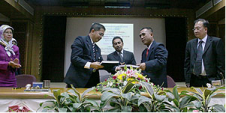
A B$9.5 million project for the delivery of Borneo's national Spatial Data Infrastructure (NSDI) was officially contracted on 22nd April during a signing ceremony between the Ministry of Development and...
Caris (Canada) has released Core Production Database (CPD) version 2.5. Using Oracle data processing, CPD is a seamless, geospatial database that enables stakeholders to consolidate their data into a single...

Optech Incorporated, based in Vaughan (Toronto), Canada, virtually brought Light Detection and Ranging (Lidar) to the survey world. Starting as a small R&D enterprise over 35 years ago, Optech has...

Geomares Publishing (The Netherlands) is proud to announce the appointment of Mark Pronk as the new technical editor for GIM International and Hydro International. Prior to taking up his...
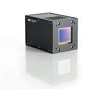
Teledyne DALSA, Canada, is to showcase its multispectral, aerospace, IR and custom CCD and CMOS sensors and cameras at the upcoming SPIE Optics & Photonics trade show, located at the...
After taking part in a competitive tender process, CARIS has been awarded the National Survey Storage System project from Rijkswaterstaat. The software will be utilised in the processing, storage and...
This site uses cookies. By continuing to use this website, you agree to our Cookies Policy. Agree