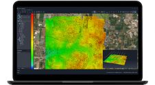
Found 7862 results
Sort by

Danish Aerial Mapping Company

As part of Fugro's strategy to expand its Aerial Mapping services business in Europe, a new company - Fugro Aerial Mapping A/S - has been established in Denmark to provide...

Read more

Linda Foster

Linda Foster oversees Esri’s worldwide strategic vision for land administration and surveying. With 20 years of experience working in the land and resource industry, she is a registered professional land...

Read more

CHCNav introduces AlphaUni 20 Lidar system

The AlphaUni 20 (AU20) Lidar system represents a new era in cost-effective, multi-platform mobile mapping solutions, according to CHC Navigation (CHCNav), a global leader in precision mapping, positioning and navigation...

Read more

SimActive announces upgraded cloud capabilities

SimActive has unveiled the enhancement of Correlator3D for improved cloud environment productivity. With Correlator3D’s distributed processing capabilities, clients can seamlessly scale their processing in line with operational needs. The challenges...

Read more

ZZCOMM Technology Co Ltd

Founded in 2017, ZZCOMM technology of geospatial hardware and software solutions provides rapid and high-accurate geospatial data for BIM, mining AEC, survey and mapping industries, whether they are indoor, outdoor,...

Read more