Airborne Lidar

RIEGL has announced the launch of two innovative topobathymetric scanners. These advancements mark a shift towards enhanced efficiency and precision in data collection across land and water interfaces. The RIEGL...
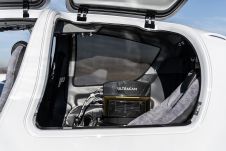
Diamond Aircraft and Vexcel Imaging have announced the next collaboration for a further expansion of Diamond’s special mission aircraft high-end sensor portfolio. The partnership will integrate the UltraCam Dragon 4.1...

Visitor registration is now open for GEO Business, the UK's largest geospatial event. The free-to-attend expo, tailored for geospatial professionals seeking to harness the potential of location intelligence, will return...
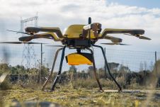
YellowScan, a familiar name in the mapping and land surveying realm, is making a noteworthy entrance in the hydrographic sector with the introduction of its pioneering UAV-based bathymetric Lidar solution....

At the experimental forest site Paracou in French Guiana, a range of data is being collected to enable the short-term dynamics within the tropical rainforest canopy to be better understood...
The first commercial airborne Lidar systems appeared on the market in the mid-1990s. This active remote-sensing technology rapidly evolved to become the laser scanners which can today emit 400,000 pulses...
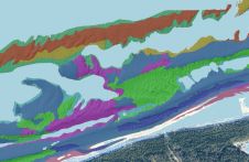
This article presents a novel methodological approach to understand and assess the suitability of airborne Lidar bathymetry for the automatic classification and mapping of the seabed. This solution allows recording of...
Although operational for more than twenty years, Airborne Lidar Bathymetry (ALB) has rarely been used in riverine areas. The US Bureau of Reclamation adopted it to study how flow change...
This site uses cookies. By continuing to use this website, you agree to our Cookies Policy. Agree