Port of Rotterdam Authorities
Rotterdam is Europe’s largest logistical and industrial hub and its port is the gateway to a European market of 450 million consumers. It is accessed by five competing modes: road,...
Rotterdam is Europe’s largest logistical and industrial hub and its port is the gateway to a European market of 450 million consumers. It is accessed by five competing modes: road,...
Intermap Technologies Corp. (CO, USA) has announced an engineering innovation and technological advancement to an industry-leading radar collection technology - IFSAR (Interferometric Synthetic Aperture Radar). The company has reached a...
EarthData International (EarthData) (MD, USA) has been awarded a US$4.3 million contract from the National Geospatial-Intelligence Agency (NGA) to map portions of one of South America’s largest countries using the...
Geodis Brno operates in the fields of surveying, photogrammetry and sales of survey equipment. Established in 1990 as one of the first private companies in former Czechoslovakia, the company has...

Taylor and Francis (The Netherlands) has announced a new publication in the ISPRS Book Series, Advances in Mobile Mapping Technology. The publication was edited by C. Vincent Tao of Microsoft...
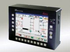
Leica Geosystems (Switzerland) has released new versions of its FCMS (Flight & Sensor Control Management System) and FPES (Flight Planning & Evaluation Software). FPES is an office tool for flight...
Diamond Airborne Sensing (Austria) has introduces the DA42 MPP (Multi Purpose Platform) twin engine aircraft is perfectly suited for carrying multifunctional airborne sensors, which combines the advantages and flexibility of...
Fugro (The Netherlands) acquires 100% of the shares of the USA based EarthData group which has its main office in Frederick (MD, USA) and includes Horizons Inc., based in Rapid...
At the end of the tumultuous eighteenth century the British government ordered its Board of Ordnance, the defence ministry of its day, to survey the country’s south coast. Today Ordnance...
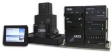
Applanix (Canada) has introduced the Digital Sensor System (DSS) 439, a medium format airborne directly georeferenced imaging solution. The DSS 439 incorporates the latest advances in direct georeferencing and 39MegaPixel...
This site uses cookies. By continuing to use this website, you agree to our Cookies Policy. Agree