Lidar in surveying & mapping
Lidar, short for Light Detection and Ranging surveying, represents a sophisticated measuring system leveraging the power of light. Widely recognized for its versatility, Lidar is extensively applied in diverse fields...
Lidar, short for Light Detection and Ranging surveying, represents a sophisticated measuring system leveraging the power of light. Widely recognized for its versatility, Lidar is extensively applied in diverse fields...
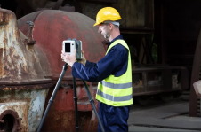
Artec 3D has introduced the Artec Ray II, a highly precise 3D Lidar scanner specifically designed for digitizing large objects and spaces with exceptional speed and accuracy. Artec 3D is...
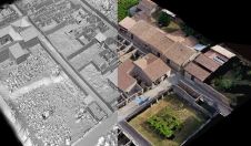
Researchers have been using GIS and 3D modelling techniques to create highly accurate maps of Pompeii. This has led to the development of a digital twin of the ancient Italian...
The International Association of Landscape Archaeology (IALA) has chosen a PhD thesis titled 'Learning to look at Lidar: combining CNN-based object detection and GIS for archaeological prospection in remotely-sensed data'...
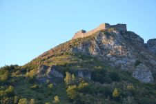
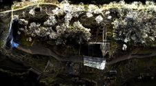
The city of Carcassonne in the south of France hopes to obtain UNESCO World Heritage certification for its sentinel mountain castles, better known as Les Châteaux Cathares. Built in the...
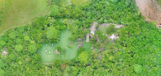
A RIEGL VZ-400i 3D terrestrial laser scanner was deployed in Peru to create a high-resolution digital 3D terrain model of an ancient fortress. This is a good example of how...
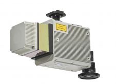
Teledyne Geospatial has introduced the Optech CLS-A, a new survey-grade UAV Lidar and camera system. The Optech CLS-A is developed for high-quality surveying and inspection applications where the tight integration...
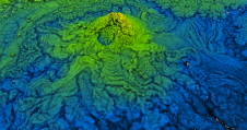
While it is possible to capture ancient Maya sites hidden beneath jungle canopy in remote locations using airborne Lidar, identifying them is still a time-consuming process. Typically, 3D point clouds...
These inspiring articles all prove the versatility of the brilliant technology that is Lidar. Sensor miniaturization has made Lidar technology easier to integrate, enabling applications such as UAV-based and handheld...
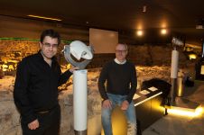
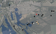
The Terra Mosana project is reinforcing the shared history in the territory where Germany, Belgium and the Netherlands meet. Today’s official country borders are relatively new, and geomatics can be...
This site uses cookies. By continuing to use this website, you agree to our Cookies Policy. Agree