Endangered Peruvian fortress secured by modern mapping methods
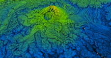
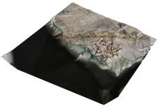
A RIEGL VZ-400i 3D terrestrial laser scanner was deployed in Peru to create a high-resolution digital 3D terrain model of an ancient fortress. This is a good example of how...

A RIEGL VZ-400i 3D terrestrial laser scanner was deployed in Peru to create a high-resolution digital 3D terrain model of an ancient fortress. This is a good example of how...

Teledyne Geospatial has introduced the Optech CLS-A, a new survey-grade UAV Lidar and camera system. The Optech CLS-A is developed for high-quality surveying and inspection applications where the tight integration...
These inspiring articles all prove the versatility of the brilliant technology that is Lidar. Sensor miniaturization has made Lidar technology easier to integrate, enabling applications such as UAV-based and handheld...
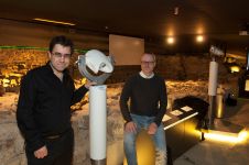
The Terra Mosana project is reinforcing the shared history in the territory where Germany, Belgium and the Netherlands meet. Today’s official country borders are relatively new, and geomatics can be...

Michael Klein has been active as the CEO of 7reasons, Vienna, Austria, in the fields of virtual archaeology and digital cultural heritage for over two decades, with a special interest...
More than 500,000 aerial images of historical sites in England have been used for a new mapping tool. Photographs and 3D laser scans taken over the past 30 years have uncovered "hidden...
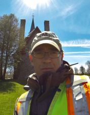
Jonathan Fowler teaches in the Anthropology Department at Saint Mary’s University in Halifax, Canada, and has operated Northeast Archaeological Research since 1998. A two-time Commonwealth Scholar, Jonathan holds an MA...
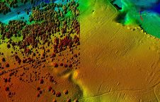
Airborne Lidar and 3D modelling technologies were used at the historic site of Fort Anne in Nova Scotia, Canada, not only as an aesthetic recreation of history, but also to...
IDS GeoRadar, part of Hexagon, has enhanced IQMaps, its post-processing software application for advanced GPR data analysis. The updated version includes new functionalities that improve the visualization of radar data...
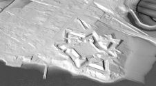
A Canadian archaeologist is using advanced mapping and visualization technologies to bring one of the earliest European settlements in North America back to life. Dr Jonathan Fowler combined a centuries-old...
This site uses cookies. By continuing to use this website, you agree to our Cookies Policy. Agree