3D city models and their multitude of purposes
At Aalto University, research has focused on ways to use 3D city models in the capital region of Finland and on applying new 3D mapping technologies to the modelling of...

At Aalto University, research has focused on ways to use 3D city models in the capital region of Finland and on applying new 3D mapping technologies to the modelling of...
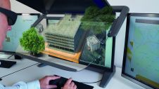
The cooperation between Schneider Digital and Xeometric/ Elitecad optimally combines the strength of 3D planning capabilities and stereoscopic graphic output. Three-dimensional modelling and design with Elitecad can be viewed stereoscopically...
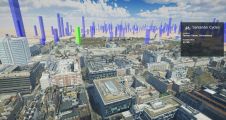
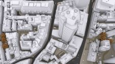
Photorealistic 3D models are being used to produce a new interactive map of London. Created by the Centre for Advanced Spatial Analysis (CASA), part of the Bartlett Faculty of the...

3Dsurvey, a Slovenia-based image processing software manufacturer, is looking to expand its partner network with companies who want to support its mission to help surveyors all over the world work smarter,...

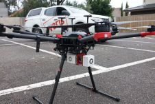
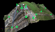
Land Surveying Drone solutions collect accurate, geo-tagged data quickly, while photogrammetry software processes these data to deliver standardized outputs. Learn how drones elevate land surveying Urban Planning Drone data creates...
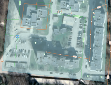
Lidar technology is synonymous with 3D point clouds. To get the most out of 3D point cloud data, it is necessary to step back and continually consider the newest trends...
Real-time monitoring can reduce long-term losses caused by holes across a network of water pipes. At 6 bar pressure, a pipe with a 6mm hole will leak 1.8 cubic metres...
In this interview Bobbie Kalra, founder of the rapidly growing Indian company Magnasoft, talks about digital twins and the future of the geospatial industry. Digital twins form the basis for...
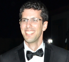
Batuhan Osmanoglu is a research physical scientist at NASA-GSFC and holds a PhD in synthetic aperture radar (SAR) interferometry. He has been a part of Istanbul Technical University, University of...
As the FIG commission chairs near the halfway point in their terms, they reflect on the global and technological drivers influencing their work. This article describes the breadth of work...
This site uses cookies. By continuing to use this website, you agree to our Cookies Policy. Agree