ESRI RouteMAP IMS 4 Shipping
ESRI (CA, USA) has announced that RouteMAP IMS 4 is now shipping. The latest release of this Internet mapping solution increases user flexibility with new out-of-the-box AJAX- and Flash-enhanced Web...
ESRI (CA, USA) has announced that RouteMAP IMS 4 is now shipping. The latest release of this Internet mapping solution increases user flexibility with new out-of-the-box AJAX- and Flash-enhanced Web...
The April 2008 issue of GIM International (page 11) summarised a project to map the Maldives as an example of how aerial photogrammetry is today applied for mapping large, complex...
Atlas for GIS and Surveying Systems Co. Ltd. is ESRI’s new distributor for GIS software in Iraq. Atlas’ persistence has begun to bear fruit with the recent announcement by the...
The November 2007 issue of Spatial Data Infrastructure - Africa (SDI-Africa), free, electronic newsletter for people interested in GIS, remote sensing, and data management issues in Africa, has been released....
National Atlas & Thematic Mapping Organization of India (NATMO) has chosen MAPublisher, a product of Avenza Systems (Canada) for their map creation needs. This Kolkata-based branch of the Indian government...
Vidar (VA, USA) has released three new 36" scanners; the Atlas 600e, Select 600e and the Nova 36e colour scanners. The Atlas 600e and Select 600e both feature 48-bit CCD...
As may be expected from a technology driven magazine, these pages are strewn with TLAs and FLAs (Three and Four Letter Abbreviations). A small selection drawn from recent bouquets includes...
RDC ScanEx (Russia), one of two organisers of the International Conference \"Earth from Space - The Most Effective Solutions\", has made available its education session program. Educational session will be...
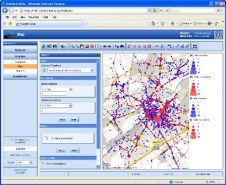
Netherlands-based road safety specialist VIA has used the TatukGIS (Poland) Internet Server for the GIS functionality in its web-based automobile crash reporting and analysis solution - ViaStat-Online. ViaStat-Online is an...
SDI-Africa has released the July 2007 issue of its electronic newsletter. Spatial Data Infrastructure - Africa (SDI-Africa) is a free, electronic newsletter for people interested in GIS, remote sensing, and...
This site uses cookies. By continuing to use this website, you agree to our Cookies Policy. Agree