Updating the Cadastre in Ecuador
Photogrammetry and Lidar were used together in Ecuador to detect irrigation and drainage canals for a project aiming to improve irrigation methods and create the related land registry. The integration...
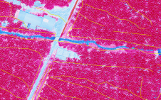
Photogrammetry and Lidar were used together in Ecuador to detect irrigation and drainage canals for a project aiming to improve irrigation methods and create the related land registry. The integration...
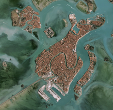
Maxar Technologies recently signed a three-year contract to continue providing its Vivid and Metro satellite imagery mosaics to Esri’s ArcGIS Living Atlas of the World. This new contract builds upon the long-term...
Airbus has enlarged its high-resolution imagery portfolio following an agreement to leverage capacity from the S1-4 satellite built by Surrey Satellite Technology Limited (SSTL). This imagery from Vision-1 delivers full...
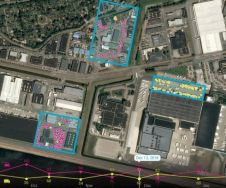
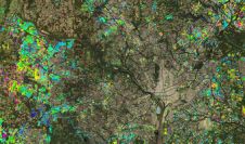
Airbus Defence and Space and Orbital Insight have expanded upon their partnership agreement to create Earth Monitor, a powerful change analysis and insights service which provides situation awareness over archived or newly...
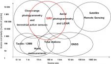
The mapping of historical cultural features, which we will call heritage mapping, is mainly based on photogrammetric methods. Mapping for this purpose has been going on for many years using...
PlanetObserver, provider of value-added geospatial data for civil and military solutions, has announced a partnership with Airbus Defence and Space, a aeronautics, space and related services company, to distribute their...
PlanetObserver, provider of value-added geospatial data for civil and military solutions, has announced a new partnership with Airbus Defence and Space, a global leader in aeronautics, space and related services,...
Maxar Technologies, a global technology innovator powering the new space economy, has announced an agreement to integrate its NaturalVue 2.0 image mosaic and National Urban Change Indicator (NUCI) commercial products...

Slingshot Aerospace, an advanced analytics company, has announced US$5 million in seed funding. The round was led by ATX Venture Partners with participation from new investor Revolution’s Rise of the Rest Seed Fund –...
Airbus Defence and Space has released a new version of the OneAtlas platform, its collaborative environment to access premium imagery, perform large-scale image processing, extract industry-specific insights and benefit from...
This site uses cookies. By continuing to use this website, you agree to our Cookies Policy. Agree