GEO Business 2024: unlocking geospatial innovation at ExCeL London
GEO Business, the UK’s premier geospatial event, is celebrating its tenth anniversary when it returns to ExCeL London on 5 and 6 June 2024. This edition promises to be the...

GEO Business, the UK’s premier geospatial event, is celebrating its tenth anniversary when it returns to ExCeL London on 5 and 6 June 2024. This edition promises to be the...

The Earth observation industry seems to be on a slow burn – but why? Brace yourself for a ‘rollercoaster ride’ through Earth observation as this article unravels the mysteries behind...

The Nemetschek Group and Hexagon’s Geosystems division are poised to establish a strategic partnership aimed at accelerating the digital transformation of their industries. As a crucial initial step, the partnership...

Woolpert has acquired Murphy Geospatial, a multidisciplinary geospatial solutions company that is headquartered in Kilcullen, Ireland. Murphy Geospatial is a private, family-owned company that delivers a broad range of services...

Looking for a recipe for business success in surveying? Don't underestimate the importance of innovative surveying services, says Moritz Lauwiner. The latest measurement sensors and software, decades of collective experience...

Despite some uncertainty, there is renewed interest in drones, and remote sensing technologies are being embraced by smaller survey companies. Read these and other findings from our annual industry survey!...

NavVis recently unveiled a substantial enhancement in global 3D spatial technology access and performance. By launching new cloud regions in the Americas and Asia-Pacific (APAC), the company aims to elevate...

Arvizio has introduced new capabilities to its enterprise XR platform with GPU-accelerated hybrid rendering to stream massive 3D models and Lidar scans to multiple participants on mobile AR devices. The...
Business Guide / Digital Twins Our traditional annual Business Guide forms a vital resource for geomatics professionals. With in-depth articles and interviews, it reflects on geospatial trends and explores the business outlook for the industry....
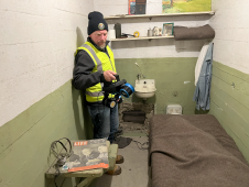
The rugged 22.5-acre site of the notorious US island prison Alcatraz has been digitally captured in a world-leading project involving multiple mapping technologies. With the team camped in the jail’s infamous cells for three weeks during the cold San Francisco winter, this historically, biologically and architecturally important location was recorded in unprecedented 3D detail. We discussed the project with project head Pete Kelsey and team member Dr Jeremy Sofonia. The rugged 22.5-acre site of the notorious US island prison Alcatraz has been digitally captured in a world-leading project involving multiple mapping technologies. With the team camped in the jail’s infamous cells...
This site uses cookies. By continuing to use this website, you agree to our Cookies Policy. Agree