12th International FIG Workshop on LADM & 3D LA
The 12th International FIG Workshop on the Land Administration Domain Model & 3D Land Administration will take place in Kuching, Malaysia, 24-26 September 2024. It will be a joint event together...

The 12th International FIG Workshop on the Land Administration Domain Model & 3D Land Administration will take place in Kuching, Malaysia, 24-26 September 2024. It will be a joint event together...

The Faroese Environment Agency, responsible for national mapping activities including land mapping and hydrographic surveying, has recently joined EuroGeographics, the representative body for European national mapping, cadastral and land registration...

There are indications that today’s technological advances are putting a fully operational multipurpose cadastre within reach, following decades of a global vision and small-scale progress towards a comprehensive map-centric land...
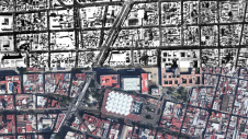
Over the past 15 years, geospatial information has enabled the transformation of towns, cities and a whole state in Mexico. The customer and data provider teamed up to create up-to-date...

The Open Maps For Europe 2 (OME2) project has revealed plans to boost the utilization of European cadastral data. This includes efforts to enhance its discoverability and accessibility. As part...

Despite the current conflict, the topographic and cadastral land-register services of the Ukrainian StateGeoCadastre are still operational, certainly in the regions where the country is not under attack. Restricted public...

Global reference systems such as the International Terrestrial Reference Frame provide the foundation for determining positions on Earth and in space, as well as for reliably quantifying our planet’s changes...
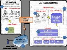
Libya has recently completed one of the biggest cadastre projects ever. A fully automated workflow has been established through all departments across the Land Registry Authority, supporting new working practices...

Over the past 20 years, various initiatives have been launched reflecting the importance of cadastral data for land management and spatial development. But how have these initiatives enhanced the possibility...
This site uses cookies. By continuing to use this website, you agree to our Cookies Policy. Agree