Anja Hopfstock
Anja Hopfstock is head of the Geodata Department at the Federal Agency for Cartography and Geodesy (BKG). The Geodata Department manages the digital landscape models at scales 1:250,000 and 1:1,000,000...
Anja Hopfstock is head of the Geodata Department at the Federal Agency for Cartography and Geodesy (BKG). The Geodata Department manages the digital landscape models at scales 1:250,000 and 1:1,000,000...
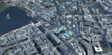
The German Federal Agency for Cartography and Geodesy (BKG) is creating a digital twin of the whole of Germany that can be used to simulate various future scenarios in order...
In this interview, Ron Bisio, senior vice president of Trimble Geospatial, provides his views on the key market trends, technology drivers and challenges, and the impacts of COVID-19 and climate...
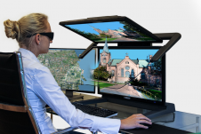
Data visualization is inherent to humans and continuously evolves, driven by innovation. How is GIS playing a role in this? The term 'data visualization' has come into popular usage relatively...
For consistent and precise digital GIS and photogrammetry workflows, raw data must first be converted into integrable and thus valuable information components that meet the requirements of the respective application...
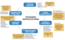
Cartography is about describing the world in the form of maps and diagrams. Classic cartography produces paper maps but nowadays this field also encompasses Geographical Information Systems and the products...
The practice of identifying and monitoring an area's physical features by measuring its reflected and emitted radiation from a distance is known as remote sensing (typically from satellite or aircraft). Researchers can "sense" facts about the Earth by using special cameras to acquire remotely sensed photos. Remote sensing is a fascinating field that revolves around the acquisition of Earth-related information without direct physical contact. It typically yields either point cloud data or imagery, both of which...
Menno-Jan Kraak is professor of Geovisual Analytics and Cartography (Faculty of ITC) at the University of Twente and ITC’s vice dean of capacity development. He was president of the International...
Lars Harrie is a professor of geomatics at Lund University, Sweden. His research interests include digitalization of urban processes, spatial analysis and cartography.
The International Cartographic Association and the United Nations recently published the book Mapping for a sustainable world. The objective was to inform those interested in visualizing SDG indicator data about...
This site uses cookies. By continuing to use this website, you agree to our Cookies Policy. Agree