Civil Design Solutions
While drones do have military pedigree, their continued development has led to a proliferation of designs suitable for almost any application where real-time data gathering is critical. This now includes...

The EAASI Summit 2023 in Lisbon in November was a resounding success. While the aerial surveying association’s fifth annual gathering highlighted the growing unity within the industry, there was also...
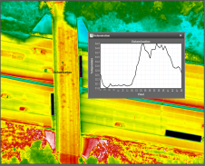
NV5 Geospatial's thermal infrared (TIR) solutions for transportation infrastructure challenges are currently being implemented in projects to analyse concrete bridges in the USA's Midwest. NV5 Geospatial, a leading geospatial data...

Jonathan Arthur Quaye-Ballard is a professor and head of the Department of Geomatic Engineering at KNUST, where he has worked for the past 20 years. He also holds a BSc...

Naa Lamkai Quaye-Ballard has worked as a consulting geodetic engineer in Ghana for over 15 years. She is currently a researcher with the Council for Scientific and Industrial Research (CSIR)...

Daniel Asenso-Gyambibi is the director of the CSIR-BRRI, Ghana. His research areas are land administration, GIS and mapping. In his 23 years’ of professional experience, he has been involved in...
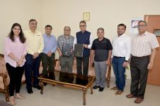
Trimble has announced a collaboration with the Indian Institute of Technology in Kanpur (IIT Kanpur) to support a new UAV programme offered by the Department of Aerospace Engineering. Trimble's contribution...
Topcon Positioning Systems has recently unveiled several initiatives in line with its ongoing commitment to sustainability. A new global team dedicated to sustainability and corporate social responsibility (CSR) has been...
This site uses cookies. By continuing to use this website, you agree to our Cookies Policy. Agree