How Computer Vision and Artificial Intelligence Boost Mapping
Reflecting the migration of people from rural areas to cities, the need to monitor and maintain urban spaces and corridors – both outdoors and in – is expanding. Automation of...
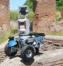
Reflecting the migration of people from rural areas to cities, the need to monitor and maintain urban spaces and corridors – both outdoors and in – is expanding. Automation of...

OmniVision, a leading developer of advanced digital imaging solutions, is working with Google's Advanced Technology and Projects (ATAP) team to develop groundbreaking vision-based mobile devices capable of tracking and mapping...
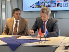
Dutch Kadaster and the Indonesian National Land Agency have signed a new Memorandum of Understanding (MoU). The two parties have been collaborating on the modernization and digitalization of land registration...

There are indications that today’s technological advances are putting a fully operational multipurpose cadastre within reach, following decades of a global vision and small-scale progress towards a comprehensive map-centric land...

Linda Foster oversees Esri’s worldwide strategic vision for land administration and surveying. With 20 years of experience working in the land and resource industry, she is a registered professional land...
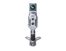
Stonex has launched a new SLAM solution for fast and efficient large-area surveys: the X70GO SLAM laser scanner. It combines mobile scanning with a stationary mode to scan with higher...
This site uses cookies. By continuing to use this website, you agree to our Cookies Policy. Agree