LINZ takes New Zealand to the cloud with 20TB aerial data
Land Information New Zealand has made 20TB of aerial imagery available for free for the first time in a cloud-optimized format on Amazon Web Services (AWS), making it easier and...
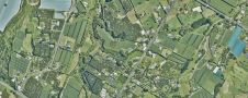
Land Information New Zealand has made 20TB of aerial imagery available for free for the first time in a cloud-optimized format on Amazon Web Services (AWS), making it easier and...
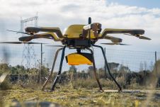
YellowScan, a familiar name in the mapping and land surveying realm, is making a noteworthy entrance in the hydrographic sector with the introduction of its pioneering UAV-based bathymetric Lidar solution....

Incorporating smart methodologies in cadastral surveying is improving the land acquisition system in Ghana. Traditional cadastral surveying is time-consuming and, if not planned out well, could cost a fortune to...

Jonathan Arthur Quaye-Ballard is a professor and head of the Department of Geomatic Engineering at KNUST, where he has worked for the past 20 years. He also holds a BSc...
Trimble and Panasonic Computer Solutions Company, manufacturer of Panasonic Toughbook mobile computers, have announced that they will provide utilities with a bundled offering specifically for utility field workers. The combination...
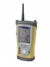
Topcon Europe Positioning B.V. (The Netherlands) has released a new field computer: the FC-200, using the Intel X-Scale 520 MHz processor. The FC-200 comes with the Windows CE operating system...
For the second time in 2009, Topcon Tierra has been honored with a construction industry award. The latest award received was the Constructech Magazine's Silver Vision Award. Earlier this year,...
This site uses cookies. By continuing to use this website, you agree to our Cookies Policy. Agree