iPad App to Create Address Database
Hamilton County, USA, is using GeoSpatial Experts’ GeoJot field data collection app on an iPad to correlate street addresses with parcel coordinates. Initiated for tax assessment and E911 purposes, this...
Hamilton County, USA, is using GeoSpatial Experts’ GeoJot field data collection app on an iPad to correlate street addresses with parcel coordinates. Initiated for tax assessment and E911 purposes, this...
GeoEye has delivered the first commercial high-resolution airport database of Kuala Lumpur International Airport to Malaysia Airport Holdings Berhad's Technical Services Division (MAHB). This product meets the new International Civil...
Avenza Systems Inc., producers of MAPublisher cartographic software for Adobe Illustrator and Geographic Imager spatial tools for Adobe Photoshop, is pleased to announce that the latest release of MAPublisher (version...

A new national street database providing details of low bridges, narrow roads and other restrictions could help to reduce satellite navigation errors. The National Street Gazetteer (NSG) lists over one...
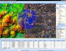
Intermap Technologies' NEXTMap Europe program has reached a milestone in December 2008 by making elevation data for the entire country of France commercially available. For the first time, uniformly accurate...
Tele Atlas has announced that the new version of its MultiNet digital map database is the first global digital map database to use community-provided data to validate changes. Released in...
Tele Atlas (MA, USA) has unveiled Tele Atlas MultiNav, the company's newest digital map platform that is designed to allow navigation application developers even greater speed and flexibility for building...
China has finished 40% of the updates of its largest national geographic information database and will complete the entire project by 2010, reported an official with the State Bureau of...
TatukGIS (Poland) announced the support for Oracle Spatial/Locator database coverages in a number of TatukGIS products. This support includes: - Reading/writing/editing Oracle Spatial vector map layers (SD_GEOMETRY) - Creation of...
Caris (Canada) has released Core Production Database (CPD) version 2.5. Using Oracle data processing, CPD is a seamless, geospatial database that enables stakeholders to consolidate their data into a single...
This site uses cookies. By continuing to use this website, you agree to our Cookies Policy. Agree