GIS in Forest Management
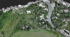
A Forest Working Plan regulates wood production, silviculture and tending activities for a predefined period of time by specifying targets, actions and control arrangements. The author shows how GIS was...
A Forest Working Plan regulates wood production, silviculture and tending activities for a predefined period of time by specifying targets, actions and control arrangements. The author shows how GIS was...
During the past year the Faculty of Geodesy at the University of Zagreb has introduced fundamental reform of all its education programmes, undergraduate, graduate and postgraduate doctoral studies, and established...
What will be the influence of a possible economic recession on the future outlook for the geomatics business? Will growth stall? Will it steadily increase, and, despite all, explode? Or...
Geokosmos has completed a LiDAR project in Krasnodar Krai (Sochi, the host city of the 2014 Olympic and Paralympic Winter Games, is located in this region). Imeretinskaya lowland and some...
Preparations are well underway for the next ISPRS Congress, which is being held in Melbourne, Australia, from 24th August to 3rd September 2012. The Conference Organiser is finalised, the web...
Multipurpose cadastres, Cadastre 2014, and sustainable land administration have radically altered understanding of cadastres and their potential over the last thirty years. Many of these concepts continue to be relevant....
ESRI and United Nations University (UNU) have approved a memorandum of understanding (MOU) at the university's headquarters in Tokyo, Japan. They will collaborate on research, create Centres of Excellence, promote...
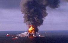
The Deepwater Horizon drilling rig was built in 2001 as a semi-submersible platform specially designed for operations in ultra-deep water. The rig employs a dynamic positioning system to maintain a...
Getmapping has launched four complimentary datasets for the whole of Wales, all derived from its 2009-2010 aerial survey. The datasets include full-colour high-resolution aerial photography, colour infrared, and two height...
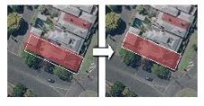
GAF AG, Germany, has made a successful contribution to Ambatovy’s biodiversity programme by applying Earth observation technology to the monitoring of forest habitats of the Republic of Madagascar. The information...
This site uses cookies. By continuing to use this website, you agree to our Cookies Policy. Agree