Lidar in surveying & mapping
Lidar, short for Light Detection and Ranging surveying, represents a sophisticated measuring system leveraging the power of light. Widely recognized for its versatility, Lidar is extensively applied in diverse fields...
Lidar, short for Light Detection and Ranging surveying, represents a sophisticated measuring system leveraging the power of light. Widely recognized for its versatility, Lidar is extensively applied in diverse fields...
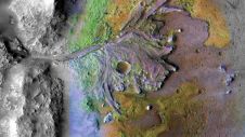
Using ground-penetrating radar, NASA’s Perseverance rover has uncovered compelling evidence of ancient lake sediment on Mars. This confirms the longstanding hypothesis that the Red Planet was once a warm, wet...
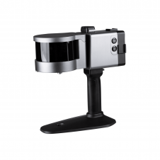
ComNav has announced the launch of its latest innovation: the LS300 3D laser scanner. This addition to the company's product lineup signifies a significant leap forward in addressing the dynamic...

Intermap Technologies, a global leader in 3D geospatial products and intelligence solutions, has been contracted to provide its high-resolution NEXTMap elevation data and precision radar imagery to support the United...
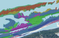
This article presents a novel methodological approach to understand and assess the suitability of airborne Lidar bathymetry for the automatic classification and mapping of the seabed. This solution allows recording of...

Ronald Koomans studied geology at Utrecht University and did his PhD at the nuclear physics lab of the University of Groningen on the application of an underwater gamma-ray spectrometer to...
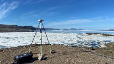
Researchers from the Bureau of Economic Geology have spent the summer in northwestern Greenland conducting research using an airborne Lidar system. The project – Airborne Lidar surveys to quantify Greenland...

This selection of articles highlights the diversity of Lidar as a flexible tool for surveying and mapping professionals. Thanks to sensor miniaturization, laser technology is available in many different guises...
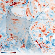
An ESA-funded campaign called PolarGAP has used airborne sensors to take a multitude of measurements to fill in the gaps in satellite coverage over the North and South Poles. It...
The U.S. Geological Survey has contracted with Woolpert to conduct a high-precision geophysical survey and subsurface geologic mapping in Arkansas. The firm will collect, process and deliver high-resolution airborne radiometric...
This site uses cookies. By continuing to use this website, you agree to our Cookies Policy. Agree