Moritz Lauwiner
Moritz Lauwiner is executive vice president and president of the Geomatics division at Hexagon’s Geosystems division. In this role, he oversees research and development, business strategy and overall management of...

Moritz Lauwiner is executive vice president and president of the Geomatics division at Hexagon’s Geosystems division. In this role, he oversees research and development, business strategy and overall management of...

Despite some uncertainty, there is renewed interest in drones, and remote sensing technologies are being embraced by smaller survey companies. Read these and other findings from our annual industry survey!...
Business Guide / Digital Twins Our traditional annual Business Guide forms a vital resource for geomatics professionals. With in-depth articles and interviews, it reflects on geospatial trends and explores the business outlook for the industry....
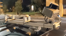
Klau Geomatics has introduced the Brumby RTK Lidar system, an innovative mobile mapping solution equipped with powerful Edge Compute capabilities, enabling the generation of highly precise georeferenced point clouds in...
Lidar, short for Light Detection and Ranging surveying, represents a sophisticated measuring system leveraging the power of light. Widely recognized for its versatility, Lidar is extensively applied in diverse fields...
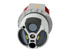
ClearSkies Geomatics, based in Colorado, USA, has recently added the RIEGL VQ-1560 II-S airborne laser scanner to its growing rental system fleet. This laser scanner, an advancement of RIEGL's dual-channel...

The EAASI Summit 2023 in Lisbon in November was a resounding success. While the aerial surveying association’s fifth annual gathering highlighted the growing unity within the industry, there was also...

Maxar Intelligence has been awarded a contract to supply the National Geospatial-Intelligence Agency (NGA) with a Precision3D Data Suite bundle. This comprehensive package covers an extensive area of 160,000 square...

Olga Bjelotomić Oršulić is an assistant professor in the Department for Geodesy and Geomatics at the University North, Croatia. Her interests include physical geodesy, geoid determination, remote sensing, tectonic movement...

Sanja Šamanović is an assistant professor in the Department of Geodesy and Geomatics at the University North in Varaždin. She previously worked in the Faculty of Geodesy at the University...
This site uses cookies. By continuing to use this website, you agree to our Cookies Policy. Agree