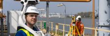
AGSE 2018: Mother Earth: Geoscience for Crisis Management
Accurate reference frames are fundamentally important for Earth science studies, satellite navigation, mapping, international time transfer and many applications relying on geospatial information. Increasingly, they are also used for demanding...

Geoscience Australia has taken the lead role in the sponsorship of the IGARSS2013 Symposium. Geoscience Australia is a leading provider of geoscientific information and knowledge enabling the Australian government to...
Geoscience Australia in Canberra has selected CARIS Bathy DataBASE software for management of large bathymetric data sets, interoperability and distribution. Geoscience Australia is Australia's national agency for geoscience knowledge and...
East View Cartographic (MN, USA) has announced that it has completed the acquisition of all Dutch mapseller RMIB Geosciences BV. The move strengthens EVC's commitment to serving its growing European...
In the first episode of NavVis’ new podcast series, we hear revelations from world experts about the past, present and future of reality capture and documentation. In the first episode of NavVis’ new podcast series, we hear revelations from world experts about the past, present and future of reality capture and documentation. ‘Scanning Realities’ is the...
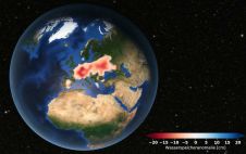
Europe is suffering from a severe drought. Satellite data analysed at TU Graz's Institute of Geodesy confirms that groundwater levels have been consistently low since 2018. Although extreme weather events...
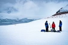
Capturing and measuring the environment in the Arctic and Antarctic is a particularly challenging job. The area of interest is often covered by a thick blanket of snow and ice,...

Roderik Lindenbergh is an associate professor at the Department of Geoscience and Remote Sensing, Delft University of Technology, the Netherlands. He obtained his PhD in Mathematics from Utrecht University, the...
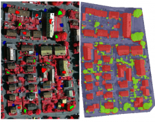
This article outlines a generic workflow for automatic buidling detection and 3D modelling using modern technologies, to support applications ranging from urban planning and cadastre to change detection and navigation....
This site uses cookies. By continuing to use this website, you agree to our Cookies Policy. Agree