UAV Spectral Image Mapping of Shoreline Vegetation
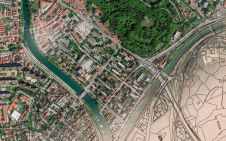
An affordable DJI Phantom 3 drone with built-in camera, which collects data only in the visible spectral bands, has been used to identify shoreline, vegetation and water. Rapid identification of...
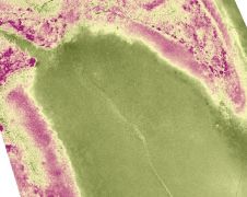
An affordable DJI Phantom 3 drone with built-in camera, which collects data only in the visible spectral bands, has been used to identify shoreline, vegetation and water. Rapid identification of...
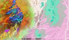
GAF has recently completed an ESA-funded project to support the African Mineral Geoscience Initiative (AMGI). The World Bank-initiated AMGI project is a pan-African initiative for the collection, consolidation, interpretation and...
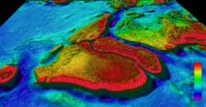
One and a half million square kilometres of bathymetric seafloor data have been released to the public by Geoscience Australia under partnership with James Cook University and the Australian Hydrographic...
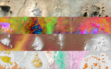
The traditional way of mapping Earth’s geology and mineral resources is a costly and time-consuming undertaking. While satellites cannot entirely replace the expert in the field, they can certainly help...

ESA’s CryoSat mission has revealed that, over the last seven years, Antarctica has lost an area of underwater ice the size of Greater London. This is because warm ocean water...
According to Wikipedia, “a cadastre (also spelled cadaster), using a cadastral survey or cadastral map, is a comprehensive register of the real estate or real property’s metes-and-bounds of a country”....

Simon Buckley, PhD, has a background in geospatial science. He has worked at the interface between geomatics, 3D visualization and earth science for over 20 years, as a researcher in...
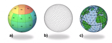
The Open Geospatial Consortium (OGC) has approved the Discrete Global Grid System (DGGS) as OGC Abstract Specification - Topic 21 [OGC 15-104r5]. The goal of DGGS is to enable rapid...
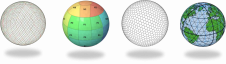
The membership of the Open Geospatial Consortium (OGC) has approved the Discrete Global Grid System (DGGS) as OGC Abstract Specification - Topic 21 [OGC 15-104r5]. The goal of DGGS is...

A number of weeks ago, I made contact with a certain Perry Peterson, the founder of a Canadian-based company called PYXIS, in order to request an interview about the Open Geospatial Consortium’s...
This site uses cookies. By continuing to use this website, you agree to our Cookies Policy. Agree