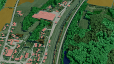
Found 2755 results
Sort by

Bahrain Spatial Data Infrastructure

    The National Spatial Data Infrastructure (NSDI) for the Kingdom of Bahrain was officially implemented in February 2005 by the GIS Directorate of the Central Informatics Organisation (CIO), Kingdom...

Read more

Web-based Infrastructure Management

The geoportal software g.on aimPort will be represented at CeBIT 2011 in Hanover, to be held from 1st to 5th March 2011. Potential clients are mostly operators of industrial plants,...

Read more

Bentley Appoints Infrastructure Ambassadors

Bentley Systems has launched the Bentley Infrastructure Ambassadors Council. The newly appointed ambassadors will engage the global communities of practitioners, constituents, and organisations interested in the challenges of and opportunities...

Read more

Utilities Infrastructure Management Solutions

Intergraph is expanding its proven utilities infrastructure management solutions with new, open standards-based spatial data infrastructure (SDI) capabilities to foster greater interoperability. Intergraph SDI capabilities enable secure, fast and seamless...

Read more

Infrastructure Modelling Software

Autodesk's new Infrastructure Modelling software products facilitates users in utilities, telecommunications organisations and government agencies improve the design and management of their infrastructure. Autodesk's portfolio of products - including AutoCAD...

Read more

Victorian Rail Infrastructure Survey

Geomatic Technologies (GT) (Australia), with the Department of Infrastructure (DOI), has completed the Victorian Rail Infrastructure Survey and Pass Assets project. The project involved producing a register of assets associated...

Read more