Surveyor 2.0, Land Administration and More
Richard Groom provides pointers to articles from the FIG Congress in May. Papers can be downloaded from https://bit.ly/2yz8xlB. Changing Survey Muller and Klein (TS06C) look at moves to update the...
Richard Groom provides pointers to articles from the FIG Congress in May. Papers can be downloaded from https://bit.ly/2yz8xlB. Changing Survey Muller and Klein (TS06C) look at moves to update the...

its4land is an EU-financed project to assist Kenya, Rwanda and Ethiopia in mapping land tenure more quickly, cheaply and transparently. It will end in three years’ time; right now, the...
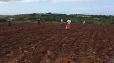
In October 2015, Gugile Nkwinti, the Minister of Rural Development and Land Reform (DRDLR) South Africa, launched the 'One Household, One Hectare' programme. The plan is to allocate a one-hectare...
The Expert Group Meeting on Secure Tenure: ‘New legal frameworks and tools’, was held at the UN Conference Centre in Bangkok from 8th to 9th December 2005. More than fifty...

Linda Foster oversees Esri’s worldwide strategic vision for land administration and surveying. With 20 years of experience working in the land and resource industry, she is a registered professional land...

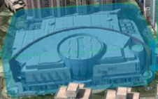
There are indications that today’s technological advances are putting a fully operational multipurpose cadastre within reach, following decades of a global vision and small-scale progress towards a comprehensive map-centric land...

Intermap has won a US$20 million contract to map the Indonesian island of Sulawesi this year. The contract is the first phase of the Indonesian national topographic basemap programme to...

The AlphaUni 20 (AU20) Lidar system represents a new era in cost-effective, multi-platform mobile mapping solutions, according to CHC Navigation (CHCNav), a global leader in precision mapping, positioning and navigation...
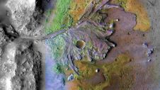
Using ground-penetrating radar, NASA’s Perseverance rover has uncovered compelling evidence of ancient lake sediment on Mars. This confirms the longstanding hypothesis that the Red Planet was once a warm, wet...
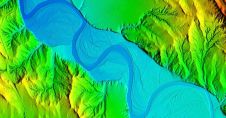
Woolpert has secured a contract with the University of Wyoming to generate a digital terrain model and contours. Leveraging Lidar data previously acquired for the United States Geological Survey (USGS),...
This site uses cookies. By continuing to use this website, you agree to our Cookies Policy. Agree