Laser Scanning on the Go
As the world's population keeps growing and changes in buildings and infrastructures become more rapid, there is an increasing need to document this growth and these changes. A revolutionary approach to...
As the world's population keeps growing and changes in buildings and infrastructures become more rapid, there is an increasing need to document this growth and these changes. A revolutionary approach to...
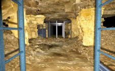
Laser scanning technology has been used to create a permanent and lasting record of post-mediaeval underground mines under the city of Bath, UK. The project by Oxford Archaeology employed laser...
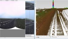
High measurement rates and centimetre precision point-clouds are state-of-the-art in mobile laser scanning. The introduction of photogrammetric features as next logical step considerably expanded the horizon of potential applications. Digital...

JOUAV has released the JoLiDAR-1000 Lidar sensor designed specifically for uncrewed aerial vehicles (UAVs or ‘drones’) as the latest addition to its array of high-performance Lidar sensors for use in...
Optech is to organise its fifth International Terrestrial Laser Scanning User Meeting on 8th and 9th June 2010 in Prague, Czech Republic. Optech clients and expert users of static and...
Last month we reported back from the Intergeo trade show that it was all about three abbreviations: Airborne Laser Scanning (ALS), Terrestrial Laser Scanning (TLS) and Mobile Laser Scanning (MLS)....
Mosaic has partnered with Movella aimed at redefining precision and efficiency in mapping and 3D reconstruction projects. Mosaic is specialized in mobile mapping camera systems, while Movella is a renowned...

Visitor registration is now open for GEO Business, the UK's largest geospatial event. The free-to-attend expo, tailored for geospatial professionals seeking to harness the potential of location intelligence, will return...

Sven Cowan is NV5 Geospatial’s Programme Manager for Canada. He has over 20 years of experience in customer-facing positions within the geospatial information industry and has worked for multiple geospatial...

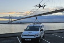
A topobathymetric Lidar survey was conducted to support flood preparedness in Canada. Which techniques achieved exceptional precision, and what were the logistical challenges? Find out more in this article. As...
This site uses cookies. By continuing to use this website, you agree to our Cookies Policy. Agree