Bringing BIM Down to Earth
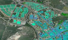
‘BIM’ is a hot topic in the industry, receiving regular coverage at many conferences, seminars and webinars. A lot of companies predict that it is one of the ‘next big...
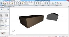
‘BIM’ is a hot topic in the industry, receiving regular coverage at many conferences, seminars and webinars. A lot of companies predict that it is one of the ‘next big...
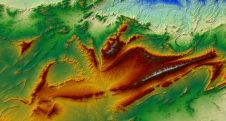
The remarkable capabilities of airborne Lidar continue to improve, with scanners now able to emit more than a million pulses every second. Although it has never been easier to acquire...
The international infrastructure group Balfour Beatty is reaping the rewards of using drones on major construction projects, including work on a multi-million-pound 'Smart Motorway' upgrade in the Midlands region of...

thinkWhere is developing an online mapping portal to improve access to official European geospatial open data. Working with EuroGeographics, as part of the Open European Location Services (Open ELS) project,...
GAF AG, together with e-GEOS, has been awarded a framework contract by the European Union Satellite Centre for the provision of satellite-based digital elevation models to support the validation of...

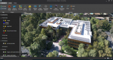
Digital Construction Week 2018 returned to Excel in October as an exhibition, with a main stage for paid conference sessions and several ‘theatres’ within the exhibition space. This article gives...
The remarkable capabilities of airborne Lidar continue to improve, with scanners now able to emit more than a million pulses every second. Although it has never been easier to acquire...
A cloud-based cadastre-as-a-service platform in New South Wales (NSW), Australia, has gone live to overhaul the state's approach to managing cadastral data. Representing a major upgrade to the process for...
In early September 2018, it was announced that Esri and 3DR have partnered up to develop Site Scan Esri Edition. This end-to-end package includes full mission planning to easily capture...
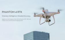
DJI, a world leader in civilian drones and aerial imaging technology, has announced the global rollout of the Phantom 4 RTK, a high-precision aerial survey drone that combines centimetre-level navigation...
This site uses cookies. By continuing to use this website, you agree to our Cookies Policy. Agree