Chasing BIM: How Surveyors Can Shape the Future
Survey and geospatial professionals can still do more to deliver value in the 3D environment. Learn how to leverage the BIM revolution for business benefits with these practical insights. While...

Survey and geospatial professionals can still do more to deliver value in the 3D environment. Learn how to leverage the BIM revolution for business benefits with these practical insights. While...

In the following interview with GIS Professional, Satish Sankaran and Chris Andrews speak to Niall Conway about their work on Esri's 'Open Strategy' and about where the GIS industry is...
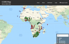
Continuously operating reference stations (CORS) are permanent GNSS stations that log and disseminate GNSS observations continuously to meet various user needs. CORS networks have been going up all over the...

The idea behind INSPIRE is quite simple: a common framework for all European environmental reference data. The implementation of such a system, however, is less simple. Technology is one thing...

A spatial data infrastructure (SDI) seeks to harmonise users with the provision of data, metadata, software and computational services to provide a productive and flexible environment for working with geospatial...
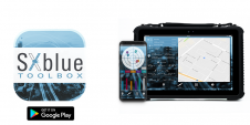
Geneq (SXblue) has introduced the SXblue ToolBox, the Android application for SXblue GNSS receivers. The application has been developed with special consideration to modern mobile device development and attention to...

Digital Construction technology provider 3D Repo has announced software that identifies clashes in construction plans by analysing 3D models submitted by project partners and contractors. The new Clash Detection functionality...
GeoSpock, the extreme-scale data integration company that provides analytics, builds insight, and enables predictions across space and time, has announced the launch of its Location Intelligence as a Service (LlaaS) Product Showcase....

The European Space Agency (ESA) has raised its Open Geospatial Consortium (OGC) membership level from Technical to Strategic – OGC’s highest level of membership. As a Strategic Member, ESA will...
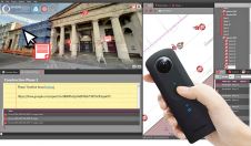
SphereVision is revolutionising the use of 360 degree imaging with the release of SphereVision Project. An intuitive end to end solution, the suite is designed to bring together 360 degree...
This site uses cookies. By continuing to use this website, you agree to our Cookies Policy. Agree