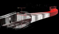
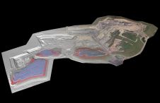
Found 4741 results
Sort by

Representing 3D point cloud data

Read this guide to the main 3D data representation methods to understand the key differences and choose the best method for your specific applications. The 3D data jungle in today’s...

Read more

Machine-learning Point Cloud Classification

Pix4Dmapper is an industrial-standard photogrammetry software package that provides accurate 3D reconstruction from overlapping images. Along with the expanding drone market, people are keen to explore new solutions to replace...

Read more

Background to Point Cloud Software

To be useful, the millions or even billions of 3D points generated by a variety of active and passive sensors need to be stored, organised, combined, georeferenced, measured and analysed,...

Read more

Insight into Point Cloud Software

To be useful, the millions or even billions of 3D points generated by a variety of active and passive sensors need to be stored, organised, combined, georeferenced, measured and analysed,...

Read more

MicroSurvey Point Cloud CAD 2010

The Point Cloud CAD 2010 is Microsurvey's latest product that allows the individual to work with Point Cloud and LIDAR data with ease. MicroSurvey has spent the last year working...

Read more

AutoCAD Point Cloud Plug-In

Point clouds are increasingly beginning to prove their worth in the construction industry, but the ability to work with point clouds within AutoCAD has been limited. Pointools Model makes it...

Read more

Survey and Point-Cloud Software

Virtualgeo was established in 1994 as a spin-off from an established survey company active in the field of topographic survey and infrastructure planning since 1985. Virtualgeo has three offices in...

Read more