RIEGL Launches iPad Point Cloud Viewer
RIEGL has introduced an app, called RiALITY, for Lidar data visualisation. The app allows users to experience Lidar data in a completely new environment and also allows easier Lidar data...
RIEGL has introduced an app, called RiALITY, for Lidar data visualisation. The app allows users to experience Lidar data in a completely new environment and also allows easier Lidar data...
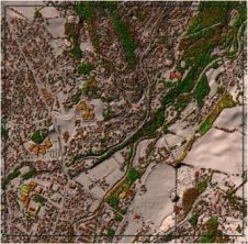
Why base the terrain model in infrastructure projects on 'old' contour maps when you can get a fresh and more accurate representation of the terrain based on laser scanning? That's...
Gexcel (Italy) is launching a new point cloud streaming service based on a web application. It will launch this application during Intergeo, to be held from 8 to 10 October...
Topcon Positioning Systems (TPS) new ScanMaster version 1.5 software is designed to simplify laser scanner point collection and manipulation. ScanMaster software is used with Topcon's GLS-1000 scanner, a compact and...
SimActive has announced the release of Correlator3D Version 10. This latest version comes with a completely redesigned user interface, featuring a new dark mode option, and also allows for point...
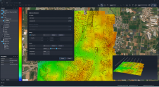
For consistent and precise digital GIS and photogrammetry workflows, raw data must first be converted into integrable and thus valuable information components that meet the requirements of the respective application...
YellowScan recently launched its software add-on module: Colorization. This third software module enhances the capability of CloudStation, YellowScan’s powerful data processing tool that provides users the ability to create and...
We rarely stop to appreciate just how complex modern surveying technology is. Surveyors use the most advanced physics, with decades of experience, in every component. Consequently, in such complex systems,...
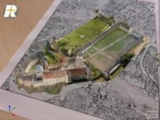
On social media, the average post receives only a few seconds of attention. At trade shows, first impressions determine whether attendees visit a booth. The first moments also set the...
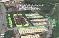
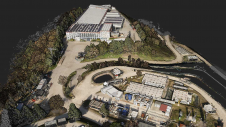
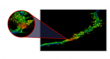
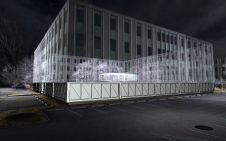
This study in Malaysia explores the use of sensor-acquired 3D point clouds as the basis for high-quality visualizations for the smart city subsurface. 3D city models are used as the...
This site uses cookies. By continuing to use this website, you agree to our Cookies Policy. Agree