Radar Satellites Show Antarctic Ice Loss
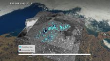
More than two decades' worth of observations by five radar satellites show the acceleration of ice loss of 30 glaciers in Western Palmer Land in the southwest Antarctic Peninsula. The study...
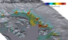
More than two decades' worth of observations by five radar satellites show the acceleration of ice loss of 30 glaciers in Western Palmer Land in the southwest Antarctic Peninsula. The study...
The issues of land ownership and land use rights are high on the Global Agenda 2030. 50% of the Sustainable Development Goals are land-related. A very rough estimation for reaching...
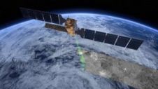
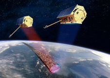
Following its orbital manoeuvres, the recently launched Sentinel-1B satellite reached its designated orbit position on 15 June. It is now orbiting Earth 180° apart from its twin, Sentinel-1A, at an altitude...

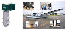
Geo-matching.com has recently added Ground Penetrating Radar to its broad spectrum of product categories. US Radar is the first supplier in this category with its 100 Series Geotechnical Systems product....
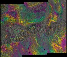
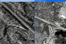
Although it was only launched a few months ago and is still being commissioned, the new Sentinel-1A radar satellite has already shown that it can be used to generate 3D...
Airbus Defence and Space, in partnership with HisdeSAT, has announced a Radar Constellation Challenge in order to encourage the development of innovative application ideas using radar satellite imagery. The initiative...
Ice in northern Alaska’s lakes during winter months is on the decline. 20 years of satellite radar imagery show how changes in our climate are affecting high-latitude environments. Changes in...
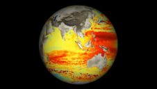
Scientists have gathered in the Italian 'floating city' of Venice this week to talk about radar altimetry: measuring the heights of the global sea surface, freshwater bodies, land and ice...
During the 4th International Conference “Earth from Space – the Most Effective Solutions” in the Moscow Region “Vatutinki” recreation center the representatives of the Italian e-GEOS company spoke about the...
A framework contract covering the acquisition and provision of TerraSAR-X radar satellite data worth EUR2.2 million, as well as the implementation of a direct ordering tool for this data, worth...
This site uses cookies. By continuing to use this website, you agree to our Cookies Policy. Agree