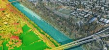
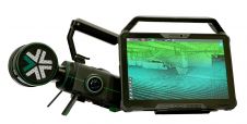
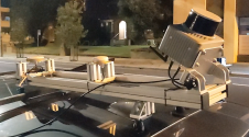
Found 6750 results
Sort by

3D geospatial visualization

3D visualization is at the heart of many geospatial data applications. Progress in 3D visualization has drastically reduced barriers to entry for new products based on large datasets, thanks to...

Read more

Real-Time Data Access

Decatur Utilities in Alabama recently upgraded its IT to provide all 165 of its employees with up-to-date network and customer data, a move that will reduce labour cost and improve...

Read more

Pioneering Real-time Visualisation

Headquartered in Tel-Aviv (Israel) and operating globally, Eternix is a software developer focused on products and solutions for high-performance visualisation of geospatial data. In recent years, the company has established...

Read more

Real-time Deformation Monitoring

Trimble has introduced today two new features for its Trimble 4D Control software solution for monitoring systems. The features include support for geotechnical sensors and a user-friendly Web Module. The...

Read more

Real-Time Web Forecasting

Snowflake Software has finished a pilot project the UK Met Office. The pilot project was a response to the needs of the UK's highway authorities to respond to continuously changing...

Read more

Real-time Real Fast Deformation Analysis

Leica Geosystems has added a software module to its GeoMoS Monitoring Software. Leica GeoMoS HiSpeed is a professional software tool for deformation analysis of high-frequency data. Together with a high-precision...

Read more