Found 6751 results
Sort by

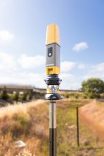
Real-time Real Fast Deformation Analysis

Leica Geosystems has added a software module to its GeoMoS Monitoring Software. Leica GeoMoS HiSpeed is a professional software tool for deformation analysis of high-frequency data. Together with a high-precision...

Read more

Near-real Time Snow Information

Satellite information on snow cover is now available through ESA's GlobSnow project soon after it snows. As well as posing a hazard to communities through transportation shutdowns and floods, snow...

Read more

Real-time Oil Spill Detection

In September-November ScanEx has performed tests with real-time water oil spills detection technique using RADARSAT-1 space images, along the northern coastline of the Caspian Sea. The data reception and processing...

Read more