Fisher Information Theory
Last time I wrote it was to discuss the application of information theory to the creation of practical tools for defining sustainable development. Such tools are sorely needed by a...
Last time I wrote it was to discuss the application of information theory to the creation of practical tools for defining sustainable development. Such tools are sorely needed by a...
LizardTech delivers wavelet-based imaging software for managing and distributing massive high-resolution digital content such as aerial photography and satellite imagery and scanned colour documents. Main products include GeoExpress with MrSID...
Leica Geosystems (Switserland) has released the new firmware version 2.10 for System 1200. This version further expands the functionality of the GRX1200 Series of GPS reference station receivers with a...
The Miage Glacier at Mont Blanc Massif, with an area totalling 11km2, is the third largest glacier in Italy. Time-space modelling of the lakebed and glacier walls carried out with...
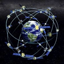
Receiver position is calculated from the position of satellites and the distances to them. Distance is calculated from the time a radio signal travels between satellite and receiver. But how...
Kingswood MapMechanics (UK) has extended its range of digital road and street map data sets. Many of its data sets cover remote parts of the world. Afghanistan and Iraq are...
Aerial photography company BlueSky (UK) has created a series of contour maps, terrain models and perspective views from archived black and white aerial photography to aid site and infrastructure development...
With the new release of TopoWorld 3D satellite imagery from Earthmate.com (ME, USA), users can unplug from the internet and map or GPS track on top of remotely sensed data,...
The fourth GML relay will be held at the Dutch Topographic Service in Emmen, The Netherlands on 26th January 2006. As explained exactly a year ago in GIM International, Geography...
The internationally supported African initiative Africa Reference Framework project (AFREF) aims at using GNSS to unify the coordinate reference systems within Africa to produce a uniform and consistent coordinate system...
This site uses cookies. By continuing to use this website, you agree to our Cookies Policy. Agree