Satellite Imagery to Shell Desktops
ER Mapper (Australia) has rolled out a new software solution for Shell exploration and production that makes Shell's twelve terabyte archive of satellite imagery available to users throughout the world....
ER Mapper (Australia) has rolled out a new software solution for Shell exploration and production that makes Shell's twelve terabyte archive of satellite imagery available to users throughout the world....
DigitalGlobe (CO, USA) and DMTI Spatial Inc. (Canada) has announce the immediate availability of Satellite StreetView. Satellite StreetView is an imagery-mapping solution combining high-quality digital mapping data with the highest...
From locating and disarming landmines to combating illegal mining, monitoring armed conflict, mapping internally displaced populations and subsequent camps as well as tracking oil pollution affecting local citizen’s health and...
Satellite Imagery Saving Lives in Conflict Zones

Urs Hugentobler is a professor of Satellite Geodesy and heads the Satellite Geodesy Research Facility of the Technical University of Munich, which operates the Geodetic Observatory Wettzell together with the...

Roland Pail is a professor of Astronomical and Physical Geodesy at the Technical University of Munich. His research activities focus on global and regional modelling of the Earth’s gravity field,...

Global reference systems such as the International Terrestrial Reference Frame provide the foundation for determining positions on Earth and in space, as well as for reliably quantifying our planet’s changes...
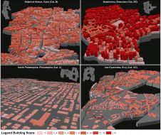
Hannes Taubenböck and his team at the German Aerospace Center (DLR) are using very high-resolution (VHR) satellite imagery, supplied by European Space Imaging, combined with auxiliary surveys to develop a...
Hannes Taubenböck and his team at the German Aerospace Center (DLR) are using very high-resolution (VHR) satellite imagery, supplied by European Space Imaging, combined with auxiliary surveys to develop a...

Airbus has announced a data-sharing agreement with satellite imagery purveyors Planet, along with a project to deliver a geoinformation platform and pipeline for the Thai government. The depth and breadth...
This site uses cookies. By continuing to use this website, you agree to our Cookies Policy. Agree