Stonex
Stonex is an Italian company, world leader in measurement and surveying. The head office is near Milan and the American headquarters is in Concord, USA. The company also has a...

Stonex is an Italian company, world leader in measurement and surveying. The head office is near Milan and the American headquarters is in Concord, USA. The company also has a...

Founded in 2017, ZZCOMM technology of geospatial hardware and software solutions provides rapid and high-accurate geospatial data for BIM, mining AEC, survey and mapping industries, whether they are indoor, outdoor,...

1Spatial has successfully secured a three-year contract with a leading distribution system operator for electricity and gas networks in Belgium. The contract, awarded after a competitive tender process, will involve...
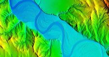
Woolpert has secured a contract with the University of Wyoming to generate a digital terrain model and contours. Leveraging Lidar data previously acquired for the United States Geological Survey (USGS),...
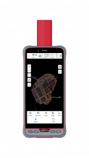
ComNav Technology has introduced its new handheld P6H. This advanced and rugged device is tailor-made for GIS data collection and outdoor operations. Featuring a GNSS high-precision positioning module, rugged IP67-rated...

Over the past 20 years, various initiatives have been launched reflecting the importance of cadastral data for land management and spatial development. But how have these initiatives enhanced the possibility...
Trimble has announced a collaboration with the Indian Institute of Technology in Kanpur (IIT Kanpur) to support a new UAV programme offered by the Department of Aerospace Engineering. Trimble's contribution...
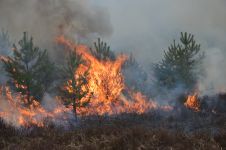
The number of wildfires has increased dramatically in recent years due to diminishing forest health caused by the drastically changing climate across the world. Longer dry-weather periods and pressure from a variety of pests and diseases, e.g. bark beetles, are affecting the large forest areas in Northern Europe. In addition to financial losses, these impacts are resulting in lower carbon accumulation and vast ecological changes. The number of wildfires has increased dramatically in recent years due to diminishing forest health caused by the drastically changing climate across the world. Longer dry-weather periods and pressure from...
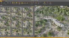
Virtual Surveyor has added drone photogrammetry capabilities to the latest release of its popular Virtual Surveyor smart drone surveying software. The new Terrain Creator app photogrammetrically processes drone photos to...

Planet was founded with the mission to image the Earth every day and make change visible, accessible, and actionable. Over the past decade with our customers, Planet has revolutionized the...
This site uses cookies. By continuing to use this website, you agree to our Cookies Policy. Agree