Linda Foster
Linda Foster oversees Esri’s worldwide strategic vision for land administration and surveying. With 20 years of experience working in the land and resource industry, she is a registered professional land...

Linda Foster oversees Esri’s worldwide strategic vision for land administration and surveying. With 20 years of experience working in the land and resource industry, she is a registered professional land...

The EAASI Summit 2023 in Lisbon in November was a resounding success. While the aerial surveying association’s fifth annual gathering highlighted the growing unity within the industry, there was also...
YellowScan, a familiar name in the mapping and land surveying realm, is making a noteworthy entrance in the hydrographic sector with the introduction of its pioneering UAV-based bathymetric Lidar solution....

Jonathan Arthur Quaye-Ballard is a professor and head of the Department of Geomatic Engineering at KNUST, where he has worked for the past 20 years. He also holds a BSc...

Daniel Asenso-Gyambibi is the director of the CSIR-BRRI, Ghana. His research areas are land administration, GIS and mapping. In his 23 years’ of professional experience, he has been involved in...

Naa Lamkai Quaye-Ballard has worked as a consulting geodetic engineer in Ghana for over 15 years. She is currently a researcher with the Council for Scientific and Industrial Research (CSIR)...

Incorporating smart methodologies in cadastral surveying is improving the land acquisition system in Ghana. Traditional cadastral surveying is time-consuming and, if not planned out well, could cost a fortune to...

Joël van Cranenbroeck is a geodesist, founder of CGEOS Creative Geosensing SRL and scientific advisor at the University of Liège, Belgium. He has extensive experience at institutions like the National...

The revolutionary use of active GNSS control points and cutting-edge geomatics equipment is setting new standards for accuracy in the construction of high-rise architecture, as demonstrated by this skyscraper project...
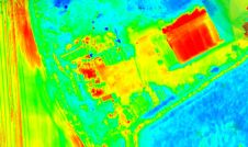
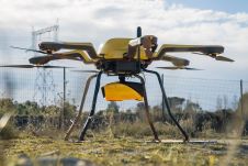
Topodrone has recently unveiled a cutting-edge drone thermal mapping solution: the Topodrone PT61 camera, designed to conduct detailed surveys and generate thermal orthomosaic maps, facilitating the creation of accurate 3D...
This site uses cookies. By continuing to use this website, you agree to our Cookies Policy. Agree