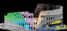
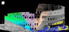
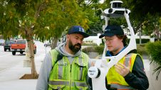
Found 4229 results
Sort by

UltraMap 2.0 Photogrammetric Software

Vexcel Imaging GmbH will roll out release 2.0 of its UltraMap photogrammetric software to customers beginning 25th January 2010. UltraMap 2.0 continues the tradition of providing a flexible and scalable...

Read more

Stratus Connect 2.0

Pitney Bowes Business Insight (PBBI) has unveiled Stratus Connect 2.0 during GeoCommunity 2009. The new features included in Stratus Connect 2.0 extend the capabilities of the definitive location intelligence tool...

Read more

Where2.0Now?

Where2.0Now? is a one-day conference on 10th November 2009, hosted by the Association for Geographic Information (AGI) Northern Group (#AGI_NG) in partnership with the Centre for Spatial Analysis and Policy...

Read more

Disaster Mapping 2.0

There has been a recent increase in the incidence of major disasters and the damage caused, in terms both of human suffering and economic cost. UNOSAT Mapping The main goal...

Read more

TatukGIS Editor 2.0 Upgrade

TatukGIS has released the 2.0 upgrade of its desktop GIS Editor product with new features such as advanced support for coordinate systems, many new data formats, and scripting for customising...

Read more